

A spectacular document relating to the history of astronomy is brought back to light by a recent study from a group of scholars led by Jean-Marc Bonnet-Bidaud from the CEA Astrophysical Department [1]. The document, called the Dunhuang chart, now kept at the British Library in London, is a complete star atlas which was found among the 40 000 other manuscripts discovered at the Buddhist Mogao cave complex, on the Chinese Silk road in 1900. Sealed in an hidden cave around the 11th century, these manuscripts, mostly religious Buddhist texts, were miraculously preserved thanks to a dry climate.
The first detailed scientific analysis of the star chart performed by these scientists reveals that it contains more than 1300 stars and was composed around the years +(649-684). Using precise mathematical projection methods, it preserves a remarkable accuracy of 1.5 to 4° for the brightest stars. It is the oldest known star chart from any civilisation and the first pictorial representation of the classical Chinese constellations.
The chart is presented in the June 11th issue of the Nature magazine and the detailed historical and scientific study is reported in the Journal of Astronomical History and Heritage. The chart is also exceptionally on display at the British Library till 18 August 2009 to celebrate the International Year of Astronomy.
 version française version française |
 english version english version |
VIDEO

The Cave of the Thousand Buddhas
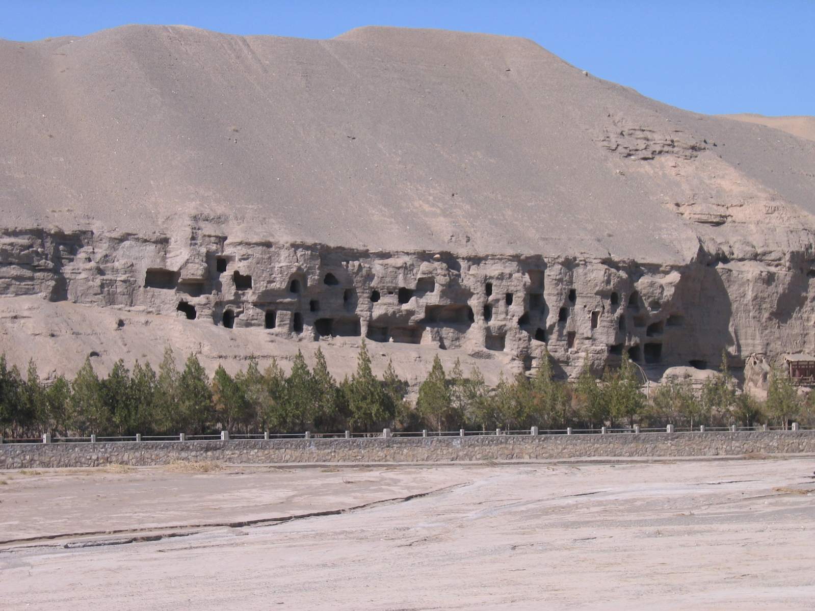
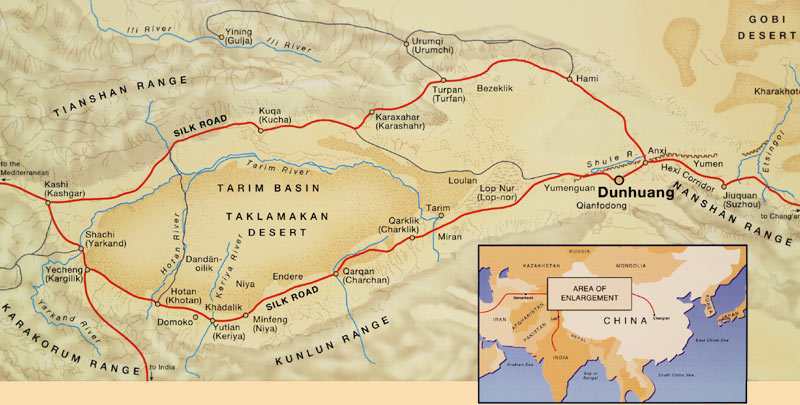
The Silk road is a legendary ancient trade route connecting China to Europe that was used as early as from the ancient Roman period. At the turn of the 19th and 20th centuries, several missions conducted by European explorers rediscovered numerous ancient cultural centres such as Buddhist monasteries often nicely decorated with spectacular murals paintings. One of these is the Mogao Cave site also known as the Caves of the Thousand Buddhas near the oasis city of Dunhuang (Gansu, China). The caves are cut into a cliff of 1600 m long and more than 480 caves are preserved.
 |
 |
| Left : the city of Dunhuang, an oasis located in the old silk Road, just east of the Taklamakan desert. Right: the Mogao Caves, a buddhist monastery made of a collection of hundreds of caves carved in a cliff . Credits British Library |

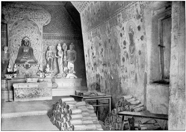
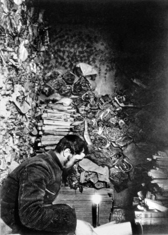
The site was active from about +360 to the end of the Mongol period. In around +1000, one cave was apparently sealed to preserve a collection of 40 000 precious manuscripts and some printed material including the world's earliest dated complete printed book. The sealed cave was rediscovered by accident and re-opened only a few years before the arrival of the British-nationalised but Hungarian-born archaeologist Aurel Stein in 1907. He was therefore the first European visitor to see the hidden library.
 |
 |
|
Left : the cave #16 where, around 1900, an hidden chamber (entrance visible at right) was discovered, containing thousands of manuscripts, all dating from before +1000. Right: the French sinologist, Paul Pelliot, one of the several explorers who enter the cache after its discovery. Credits British Library |

The dry desert climate of Dunhuang contributed to the excellent conservation of the cave's contents. Most of the Dunhuang documents are religious texts on Buddhism but there are some socio-economic documents and a few others concern medicine, divination and astronomy. Among them was a scroll of thin paper, now known as the Dunhuang star chart, that was collected by Stein among 7000 other manuscripts and sent by him to the British Museum. Though duly catalogued, it was somewhat forgotten despite the fact that its importance was noted by the famous sinologist Joseph Needham around 1955. Apart from short descriptions and partial studies done in China based on facsimile copies of the scroll, no detailed study has been produced until now.
A complete star atlas
The scientific analysis was initiated in 2004 when the chart was on display at the British Library [2] and has benefited from the help of the International Dunhuang Project, a multi-country program to digitise and distribute worldwide the content of this unique collection.
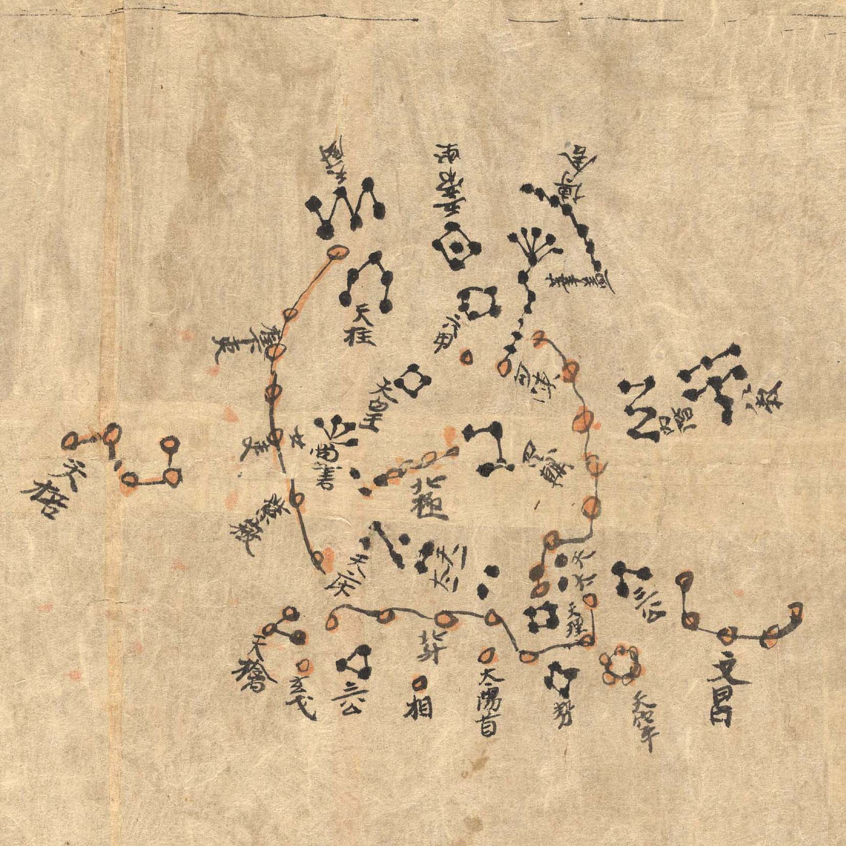
The document is a scroll of very thin Chinese paper of total length 3940 mm and width 244 mm, inscribed on one side only. The beginning of the scroll is missing and the document is divided in two different parts. The first section is an uranomancy text containing drawings of clouds of different shapes. It is followed by the detailed star atlas consisting of 12 rectangular panels along the celestial equator ending with a circular map of the polar region. A total of more than 1300 stars is distributed in 257 different Chinese constellations, according to the very long Chinese astronomical tradition described in earlier star catalogues. In particular, three different colours are used for the stars, to distinguish between the three ancient catalogues elaborated during the Warring States period (-476 to -221). The document is very finely designed by hand with most of the asterisms are labelled with their names.
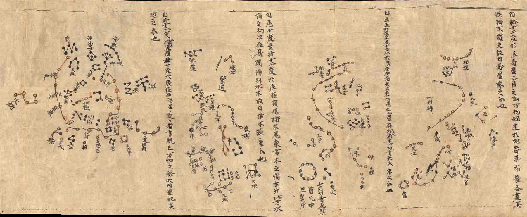
Part of the Dunhuang star chart with three sections of the sky along the equator ending with the circumpolar region (left). Credits British Library
An accurate astronomical document from the early Tang dynasty
The dating of the document proved to be a piece of real detective work. As the beginning of the scroll was missing, the title and the author was not visible. However, in the first part of the scroll devoted to clouds divination, a clear mention is made of a comment by Li Chunfeng (+602-670), an outstanding Chinese mathematican and astronomer who could possibly be the author.
The epoch is also approximately corroborated by the position of the pole on the circular chart. But the final proof came from a particularity of the Chinese tradition and writing, called the "taboos" characters. During the reign of any emperor, characters that made up the emperor's personal name were not allowed to be used in their standard form. The characters were changed slightly - usually by omitting or adding a stroke. This is known as the 'taboo' form of the character. From this, it was possible to deduced that the document was produced after the reign of the Taizong emperor (+649) and before the Ruizong emperor (+684).
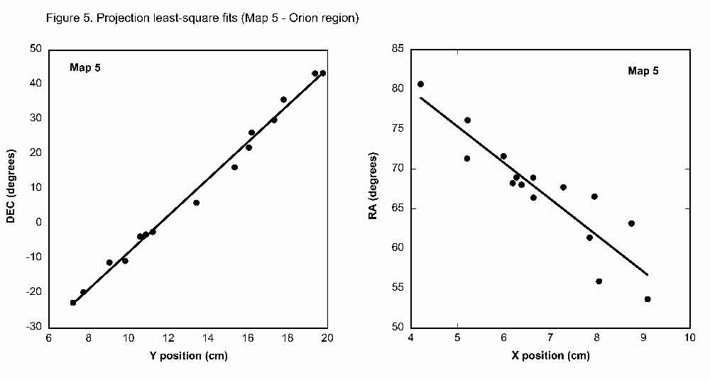
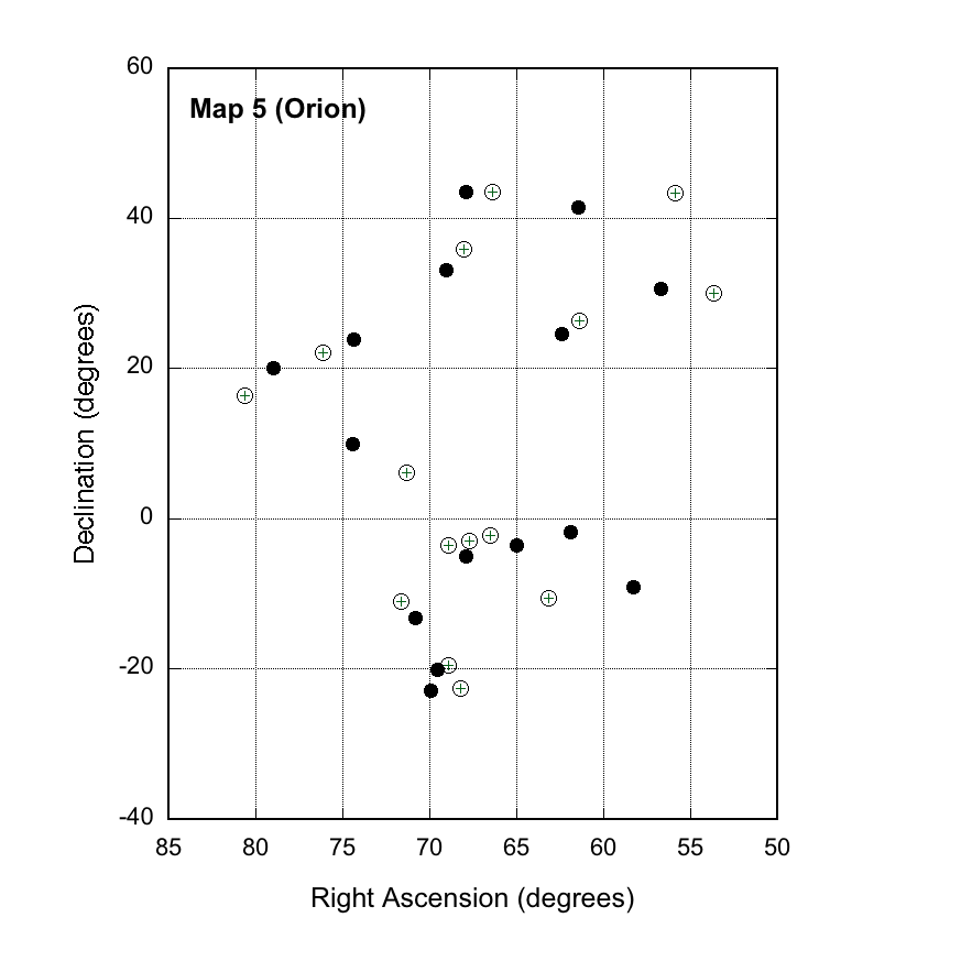
The study has also provided an evaluation of the accuracy of the atlas. The position of the brightest stars have been measured using a high resolution digitized copy of the document and compared to the predicted positions using various projection methods.
 |
 |
| The accuracy analysis of the Dunhuang chart. Left : accurate correlation between measured and predicted positions of the brightest stars in the Orion region. Right : comparison of the predicted (open circles) and measured (black dots) positions. |
This numerical study of the S.3326 document yields important results. The atlas is not a simple or hastily hand-made reminder but is established according to precise geometrical rules. The projection methods used are consistent with either a pure- cylindrical or the Mercator projection for the rectangular maps and with the azimuthal-equidistant or stereographic projection for the circular one. Such projection methods are exactly similar to the ones used today to produce our modern maps but they were only introduced in Western Europe around the XVIth century by geographers like Mercator, several centuries after their use in China.
The Dunhuang chart is the oldest preserved star chart in the world. There are reports that earlier charts may have been produced by ancient astronomers such as the Greek Ptolemy (+83-161) or the Chinese Chen Zhuo (+220-280) but no document remains from these earlier attempts. Some other artefacts are often referred to as star maps, such as the Denderah zodiac dated -50 and the Farnese globe (+150). However, both are carved on stone and only show artistic drawings of constellations without any individual stars. Outside China, the first star chart produced was the work of the Persian Al-Sufi (+986) showing for the first time individual stars but distributed into separated constellations with no information on their relative positions. In Western Europe, only the later Vienna manuscript (+1440) shows star positions in a global representation.
The Dunhuang chart, which is a complete atlas of the Northern sky, therefore predates all other works by several centuries. It also reveals a remarkable early achievement in terms of mathematical projection methods in China.
Contact :
"The Dunhuang chinese sky: a comprehensive study of the oldest known star atlas"
Bonnet-Bidaud, J.M., Praderie, F. & Whitfield, S.
published in Journal of Astronomical History and Heritage 12.1: 39-59 (March 2009) (format PDF 2.2 Mo)
pour une version electronique : astro-ph0906.2798 (format PDF, 2.2 Mo)
for an electronic version : astro-ph0906.2798 (format PDF, 2.2 Mo)
"Charting the heavens from Chine : the Dunhuang star chart"
Qiu, J. in Nature, 11 June 2009, vol 459, pp 778-779 : for an electronic version (format PDF, 1 Mo)
see also :
| The NASA Astronomy Picture Of the Day (APOD 19 June 2009) | ||
| The Telegraph (7 March 2009) |
| The Art Newspaper (March 2009) |
| Shenzhen Daily (16 March 2009, in Chinese) |
Irish Times (7 Septembre 2011)  (format PDF) (format PDF) |
more on Dunhuang manuscripts :
| The international Dunhuang Project (IDP) site |
| The IDP site at the Bibliothèque Nationale de France |
see (in french) :
|
"Des cartes célestes anciennes révèlent le génie des astronomes chinois ("Figaro Magazine", 21 Mai 2010, p. 48-50) |
| "Le trésor de la carte aux étoiles" (""Journal du CNRS", Mars 2010, n°242, p. 8) |
| ">C’est la plus ancienne carte du ciel au monde" ("Le Parisien", 16 mars 2010, p. IV) (format PDF) |
| "La carte céleste de Dunhuang" ("Pour La Science", décembre 2009, v. 386, p.90-94) (format PDF) |
| "L'ancêtre des cartes célestes est chinoise" ("Ciel & Espace", août 2008, no 459, p. 8-12) (format PDF) |
| "La plus ancienne carte du ciel sort de l’oubli" ("Journal du CEA-Saclay", 2010, v. 46, p.17-18) (format PDF) |
Video :
to obtain the full video on DVD (duration 20 minutes)
| "The Dunhuang star chart" (CNRS 2009) |
Images :
to explore the chart
| "The document S3326 (Site IDP) |
Notes :
[1] Jean-Marc Bonnet-Bidaud (Astrophysical Department of the CEA French Atomic Commission, AIM Laboratory CNRS, F) Françoise Praderie (Observatoire de Paris, F), Susan Whitfield (The Britisjh Library, UK). We are sad to announce that in the progress of this work, one of our colleagues, Françoise Praderie, an outstanding European astronomer, passed away in Paris on 2009, January 28.
[2] "Star maps and astronomy in ancient China" J.M. Bonnet-Bidaud, F. Praderie
in 'The Silk Road: Trade, Travel, War and Faith', Exhibition Catalogue, The British Library, ed. Susan Whitfield, June 2004
Rédaction : Jean-Marc Bonnet-Bidaud
